Share |
Showing posts with label storm. Show all posts

Monday, February 15, 2016

Video captures moment a tornado rips through a Tennessee high school


The eye of the storm: Astonishing security camera footage captures moment a violent 95mph tornado rips through high school leaving trail of destruction
http://dollars-vedioonline.blogspot.com/2016/02/video-captures-moment-tornado-rips.html

Remarkably no-one was injured by tornado, reported to be 100 yards wide
Security camera footage shows 95mph winds ripping through high school
Tornado damaged classrooms, the football stadium and felled lampposts


This incredible footage captures exactly what it is like to be in the path of a 95mph tornado.

The shocking video shows strong winds ripping through an American high school causing utter devastation.

Security camera footage captured the extreme weather as it swept through the grounds of Crockett County High School in Alamo, Tennessee on February 2.

Devastating tornado hits a US high school at 95 mph

Devastating tornado hits a US high school at 95 mph

The eye of the storm: Astonishing security camera footage captures moment a violent 95mph tornado rips through high school leaving trail of destructionhttp://dollars-vedioonline.blogspot.com/2016/02/video-captures-moment-tornado-rips.htmlRemarkably no-one was injured by tornado, reported to be 100 yards wide Security camera footage shows 95mph winds ripping through high schoolTornado damaged classrooms, the football stadium and felled lampposts

Posted by Oppo on Monday, February 15, 2016


Remarkably no-one was injured by the EF-1 tornado, which was reportedly 100 yards wide.
Director of Crockett County Schools, Robert F. Mullins Jr, said that the tornado's path damaged classrooms, building roofs, the football stadium and felled lampposts.


The baseball field, softball field and tennis courts also experienced minor damage caused by debris strewn across the school grounds.


Robert said there is always a possibility of tornadoes in the area during violent thunderstorms.

The tornado formed at approximately 4.55 pm around three miles west to the south west of Alamo.

The security camera shows it battering a fence at the school and throwing debris across what appears to be a parking lot.


A gate is later seen being blown open as large chunks of roofing are sent sprawling by the wind. A chair can even be seen escaping the school.
Another angle shows a flash of lightening as heavy rain adds further drama to the scene.
The tornado is listed as having ended at 5.03 pm about two miles west to northwest of Alamo.


Sunday, February 14, 2016

British skiers heading for the slopes this half-term face high risk of avalanches


British skiers heading for the slopes this half-term face high risk of avalanches due to 3ft of fresh snow and storm force winds
http://dollars-vedioonline.blogspot.com/2016/02/british-skiers-heading-for-slopes-this.html

Warnings are in place across the region after recent bout of bad weather
Poor start to the season has led to incredibly unstable snow in points
Experts describe the situation as 'explosive' with avalanches guaranteed
More than 200,000 Brits predicted to head to the region over half-term


=============================
Cheap Hotel Rooms‏
Search & Save On Cheap Hotel Rooms.
https://goo.gl/lH20lv
Save Up to 80%! Cheap Hotel Rooms.
https://goo.gl/9AI2bH

==========================


Brit skiers heading for a half-term holiday in the Alps are being warned they are at serious risk of being caught in deadly avalanches.
Storm force winds and fresh snowfall of up to a metre in places has led to mountain rescue putting resorts across the region on standby.
The avalanche risk currently stands at level four - of five - making it almost inevitable that huge slabs of snow will thunder downhill at some point, engulfing all in their path.


It is so on edge that the regional head of the French mountain rescue service, Captain Olivier Cousin, described it the whole situation as 'explosive'.
According to Meteo France: 'Across the Alps, and in particular in the interior ranges of the Haute-Savoie, Savoie, Isère and in the north of the Hautes-Alpes as well as the Haut-Var/ Haut-Verdon, the risk is high.'


With the avalanche risk across the French Alpine region at four, skiers are warned that there is a 'high probability of spontaneous avalanches' for those skiers who venture off the marked pistes.
'The main risk for off-piste enthusiasts is triggering a slab avalanche in the recent snow on all slope aspects,' the warning said.
A poor start to the snow season has led to the ranges having exceptionally icy bases.


That means the snow is incredibly unstable.
Forecasters predict more heavy snowfalls to come in upcoming days, in tandem with low temperatures.
With 10 weeks of the season left to run, the number of avalanche deaths in Europe is already at its highest for five years. Nearly all the 75 deaths, 44 of them in France and Switzerland, have occurred since New Year.


As well as the danger of avalanches, the 200,000 Brits set to head over for the week are also being warned that the fresh snow might hamper their chances of even making it to their resorts.
Road conditions are said to have become treacherous in the wake of the bad weather, with many routes already struggling to accommodate traffic.
The latest British victim, father-of-three Graeme Porteous from Wimbledon, London, died on the last day of his holiday when an avalanche swept him against a tree in the Italian Piedmont region.


Tuesday, February 9, 2016

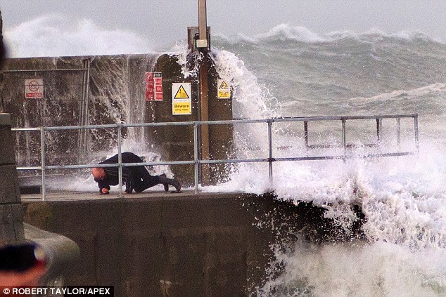
Woman taking photos of Storm Imogen is left covered in blood and suffers broken arm after being hit by massive wave and swept 50ft along Cornish seafront


Woman taking photos of Storm Imogen is left covered in blood and suffers broken arm after being hit by massive wave and swept 50ft along Cornish seafront

Couple had been photographing wild weather at South Quay, in Newquay
As they took pictures of the storm, they were knocked over by a wave
The woman suffered a broken arm after she was swept 50ft along seafront
Her partner landed on railings which stopped him falling into the harbour


A couple taking pictures of Storm Imogen had a lucky escape when they were hit by a gigantic wave and swept 50ft along the seafront.
The pair had been photographing the wild weather at South Quay in Newquay just after 4pm yesterday when they were knocked over by the colossal wave.
The woman suffered a broken arm after she landed in a boat on the quay, while her partner was washed into some railings which stopped him falling into the harbour.


A group of four RNLI (Royal National Lifeboat Institution) volunteers witnessed the entire episode and immediately went to help the terrified couple.


The woman was found extremely dazed and confused, with multiple head injuries as well as the broken arm.
Dramatic pictures show the man being knocked to the ground as the powerful wave struck.


Meanwhile, rescue teams are spending a second day searching for RSPCA inspector Mike Reid who disappeared while trying to rescue birds as Storm Imogen lashed a Cornwall beach.
Mike Reid, 54, went to save the stranded gannets at Porthchapel Beach, near Penzance, at about 2pm on Sunday, but has not been seen since.
As he was on a night shift, he was only reported missing at 6am the following morning.
His family fear he may have been swept out to sea and are anxiously awaiting news at the family home.
His wife Tracey, 45, said she feared he had fallen over a cliff and been swept into the sea.
She said: 'He loves animals and would do anything to rescue them. We are all devastated and feeling numb, but we just don't know what is happening at the moment.'
Conditions out at sea reached 'phenomenal' states, with waves topping 16m (52ft 6in) and a monster of 19.1m (63ft) recorded off St Ives.


Several people were injured yesterday, including two children who had a stone wall fall on them in Bretforton, near Evesham in Worcestershire.
The incident came less than two weeks after the local authority inspected the wall and found no immediate danger to the public.
A man in his 70s had a broken leg and his dog was killed after a garden wall blew on to them in Bognor Regis, West Sussex, at about 8am yesterday.
Meanwhile in the St Annes area of Bristol, a man in his 40s was injured after trees fell on to a three-storey block of flats.
Elsewhere, a father and daughter near Exeter had a 100ft tree blown on to their car outside their house, minutes before they were due to leave for school.


Monday, February 8, 2016

Five thousand homes left without power and commuters hit by road and rail chaos as Storm Imogen batters the South with 100mph winds and torrential rain


Five thousand homes left without power and commuters hit by road and rail chaos as Storm Imogen batters the South with 100mph winds and torrential rain
Storm batters South with 96mph winds while 280 flood alerts and warnings in place for England and Wales
Rail services in Wales and southern England facing speed restrictions and Gatwick Airport warns of delays
Almost 5,000 homes in the South West, Midlands and Wales have been left without power due to high winds
Storm Imogen expected to track eastwards along south coast throughout today and also bring 1.5in of rain


Nearly 5,000 homes were left without power today as Storm Imogen lashed Britain with hurricane-force winds that reached almost 100mph.
The storm has battered the South and gave many commuters a horrendous journey to work as trains were disrupted and ferries cancelled.
There are more than 280 flood alerts and warnings in place for England and Wales with more than 1.5in of rain expected to fall today.
Rail services in Wales and southern England are facing speed restrictions and cancellations, and London Gatwick Airport warned of delays.
And the Severn Bridge was closed eastbound and restricted westbound while ferry services from ferry companies Brittany and P&O were cancelled.


Almost 5,000 homes in the South West, Midlands and Wales have been left without power due to high winds.
Engineers have been working through the night to restore affected services, Western Power Distribution said.
Speed restrictions at various times will be imposed on routes in the South until at least 5pm due to high winds, according to National Rail Enquiries.
Affected networks include Arriva Trains Wales, Great Western Railway, Southern, South West Trains, Gatwick Express, Southeastern and Thameslink.
A Network Rail spokesman said inspections were ongoing although no damage or blockages on the network had been found.


Storm Imogen is expected to track eastwards along the south coast throughout today and threaten ferry services from the Port of Dover.
Extreme weather conditions late on Sunday forced the port to close for around two hours into this morning, disrupting services.
The authority tweeted: ‘Port of Dover is monitoring weather situation. Safety is primary concern and we apologise for any inconvenience to travellers.’
Today, there is an amber ‘be prepared’ wind warning for South Wales and England’s south coast with large waves expected in coastal areas.
The Met Office originally warned of winds up to 80mph, but overnight gusts of 96mph at the Needles off the Isle of Wight were recorded.


Forecaster Emma Sillitoe said the winds would be some of the worst so far this winter, not far off gusts of 105mph recorded last month in Shetland.
She said: ‘We are looking to see gusts of 60-70mph quite widely, hitting the South West [and] moving across southern central parts towards London.
‘It is going to be picking up towards 70mph around lunchtime in London.
‘We have seen 96mph at the Needles off the Isle of Wight and gusts to 80mph are likely, especially along northern coasts of Devon and Cornwall.’
There is also a warning for 1.6in of rain over high ground in Western Scotland and Wales and the moors of South West England today.
And the Met Office warned there was potential for an inch of snow in northern Scotland overnight into today.
Highways England warned motorists in the South to check forecasts and road conditions before travelling due to strong winds forecast up to 6pm.
The A35 running along the south coast between Devon and Hampshire has been closed in both directions near Dorchester due to flooding.
And the agency has issued a severe weather alert for ‘high-sided vehicles, caravans and motorbikes, which are advised to take extra care’.
Traffic crossing between England and Wales is being diverted in both directions via the M4 following restrictions on the M48.


So far #StormImogen has brought a max gust of 96mph to Needles Old Battery. Warnings are still in force https://t.co/BEQkezhE3z
— Met Office (@metoffice) February 8, 2016
Spokesman Jon Allen urged drivers to ‘check their routes and change their journeys accordingly’ before setting off today.
Meanwhile those watching waves in coastal areas were warned to keep a safe distance, as 45ft swells in the Channel could create dramatic scenes.
MeteoGroup forecaster Mario Cuellar said: 'It is going to be very stormy on Monday with high winds and rain, especially in the south west and Wales.
'The storm will spread eastwards during the day and could bring disruption to travel, especially Channel ferries in the late afternoon.
'This stormy weather will clear later in the week but the forthcoming weekend also looks unsettled with a low weather front coming in over the north.'
Tomorrow and Wednesday should be drier, quieter and colder days for many before more wind and rain follows later in the week.
Storm Imogen follows Storm Henry, which ran close to the north of Scotland through Monday into Tuesday of last week.
On Saturday in Cornwall the heavy rain and high winds caused flooding problems, as five vehicles became stuck in flood waters.
Sporting fixtures were also postponed with Exeter v Oxford and Bristol Rovers v Wimbledon in League Two called off due to waterlogged pitches.


Thursday, January 6, 2011

Official: Feds Probe NYC Storm Slowdown Reports 5/1/2011

Official: Feds Probe NYC Storm Slowdown Reports

Federal prosecutors in New York are looking into claims sanitation workers sabotaged the city's snow cleanup after the post-Christmas blizzard. (Jan. 5)


lets see how this plays out. If you live in Manhattan snow removal is faster, but if you live in any other borough, too bad! Garbage trucks have always been used for snow removal - cost saving, but not with this snow storm. Feds have the right to investigate; we have major highways the pass thru the city. These highways are federally funded, just like any other city or state

Thursday, November 25, 2010

Powerful Storm to Bring Snow, Ice to the Dakotas

Powerful Storm to Bring Snow, Ice to the Dakotas


A powerful storm that pummeled much of the West is promising to bring a mix of snow, sleet and ice to much of the Dakotas on Thanksgiving Day. (Nov. 24).


Monday, November 22, 2010

Western U.S. Gets Socked by First Snow

Western U.S. Gets Socked by First Snow


swath of the western United States sees its first big snowfall of the season, delighting kids and resort owners but snarling traffic in some spots. (Nov. 22)


sharing